Below is an inventory of maps prepared by GTC staff and available for your reference. This listing includes maps prepared for general reference, as well as those developed as part of the Long Range Transportation Plan. Maps developed for other specific projects and/or tasks are noted as such.
The following maps are available for download in both JPEG image format (JPG) and PDF:
GTC Nine-County Planning Region and Rochester Metropolitan Planning Area (MPA)
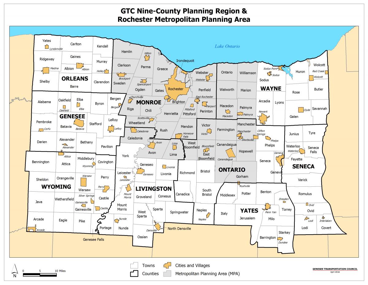
Description: This map depicts the nine-county Genesee-Finger Lakes Region, along with the Rochester MPA. The Genesee-Finger Lakes Region is the area for which GTC is responsible in terms of transportation planning and is comprised of Genesee, Livingston, Monroe, Ontario, Orleans, Seneca, Wayne, Wyoming, and Yates counties.
Developed For: No specific project
Page Orientation: Landscape
Page Size: 8.5" x 11" (Letter)
Format: JPG [467 KB]
Format: PDF [588 KB]
Rochester Metropolitan Planning Area (MPA)
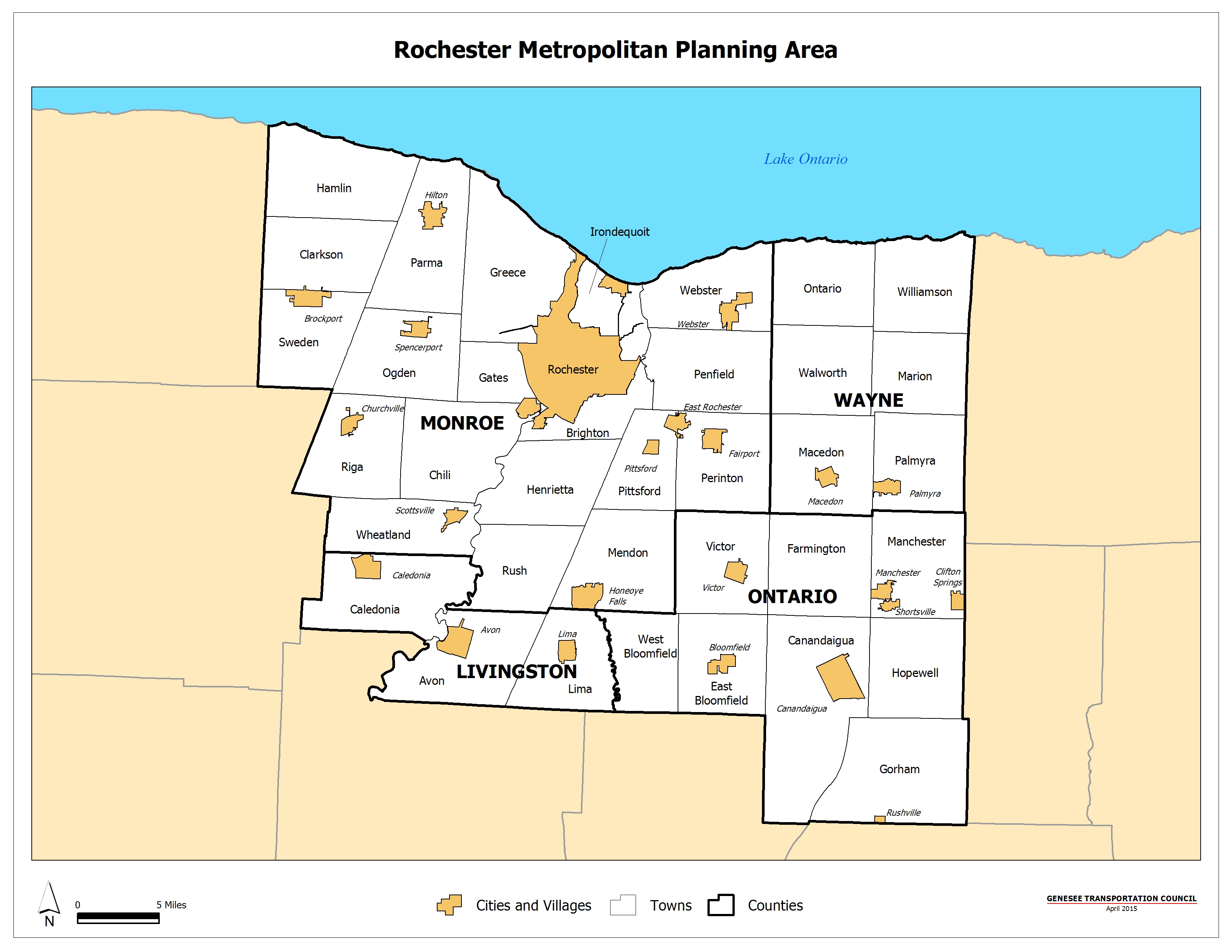
Description: This map depicts the Rochester Metropolitan Planning Area (MPA), which is comprised of Monroe County plus the adjacent developed areas of Livingston, Ontario, and Wayne counties. The Rochester MPA is the primary area of focus for GTC's transportation planning efforts.
Developed For: No specific project
Page Orientation: Landscape
Page Size: 8.5" x 11" (Letter)
Format: JPG [ 92 KB]
Format: PDF [291 KB]
Highway & Bridge Network
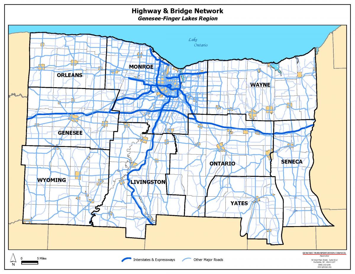
Description: This map depicts the Highway and Bridge Network of the Genesee-Finger Lakes Region. The region has over 12,000 centerline miles of State and local highways and bridges.
Developed For: 2007-2027 LRTP Update
Page Orientation: Landscape
Page Size: 8.5" x 11" (Letter)
Format: JPG [587 KB]
Format: PDF [856 KB]
Annual Average Daily Traffic (2013)
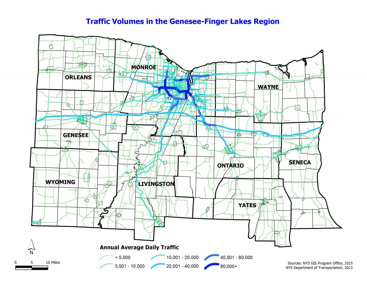
Description: This map depicts the 2013 Annual Average Daily Traffic (AADT) volumes on the State highway and bridge network in the Genesee-Finger Lakes Region. Annual daily traffic volumes are highest on the Interstates (I-90, I-490, I-390, and I-590) and on select New York State and Monroe County routes.
Developed For: LRTP 2040
Page Orientation: Landscape
Page Size: 8.5" x 11" (Letter)
Format: JPG [428 KB]
Format: PDF [650 KB]
Commuter Corridors

Description: This map depicts Commuter Corridors in the previous Rochester Metropolitan Planning Area (MPA) - often referred to as the Transportation Management Area (TMA). These corridors were identified as representing the movements made by commuters and are comprised of multiple facilities (i.e., roads, transit routes, etc.).
Developed For: NYS Department of Transportation's Statewide Corridors Strategy (2007)
Page Orientation: Landscape
Page Size: 8.5" x 11" (Letter)
Format: JPG [175 KB]
Format: PDF [276 KB]
Congested Roadways (Morning Peak Period)

Description: This map depicts the congested roadways in the Rochester Metropolitan Planning Area (MPA) for the Morning Peak Period. Congested roadway segments are defined as having a Travel Time Index (TTI) of 1.3 or greater, indicating that a trip takes one-third more time to complete during the peak period than during the off-peak period.
Developed For: LRTP 2040
Page Orientation: Landscape
Page Size: 8.5" x 11" (Letter)
Format: JPG [313 KB]
Format: PDF [346 KB]
Congested Roadways (Evening Peak Period)
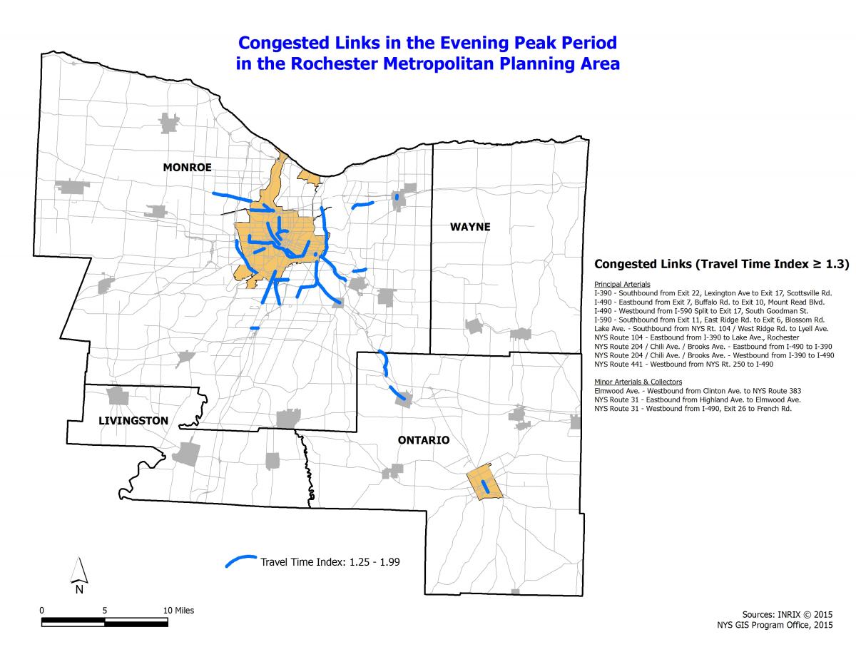
Description: This map depicts the congested roadways in the Rochester Metropolitan Planning Area (MPA) for the Evening Peak Period. Congested roadway segments are defined as having a Travel Time Index (TTI) of 1.3 or greater, indicating that a trip takes one-third more time to complete during the peak period than during the off-peak period.
Developed For: LRTP 2040
Page Orientation: Landscape
Page Size: 8.5" x 11" (Letter)
Format: JPG [450 KB]
Format: PDF [356 KB]
Multi-Use Trails Network
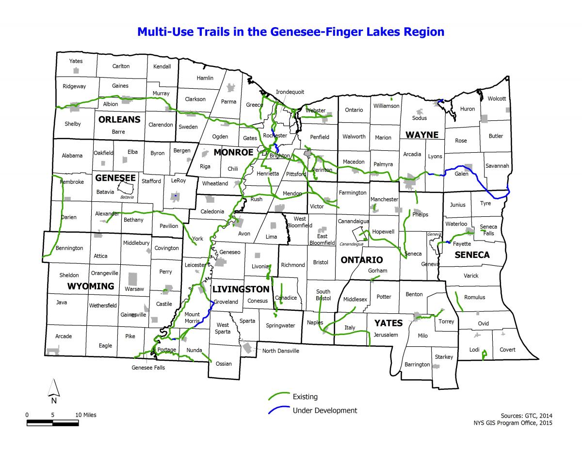
Description: This map depicts the Genesee-Finger Lakes Region's Multi-Use Trails Network. There are over 340 miles of existing trail with more than 50 miles under development.
Developed For: LRTP 2040
Page Orientation: Landscape
Page Size: 8.5" x 11" (Letter)
Format: JPG [468 KB]
Format: PDF [252 KB]
Regional Highway Freight Network
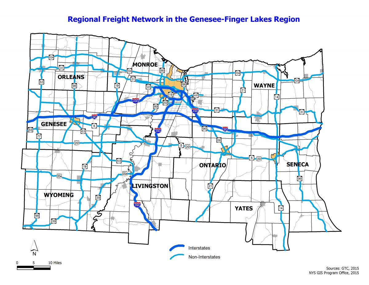
Description: This map depicts the Highway Freight Network in the Genesee-Finger Lakes Region. Made up of Interstates and NYS Routes, this network generally accomodates a higher percentage of truck traffic than the regional average, and reflects the movement of trade, both within and through the region.
Developed For: LRTP 2040
Page Orientation: Landscape
Page Size: 8.5" x 11" (Letter)
Format: JPG [404 KB]
Format: PDF [651 KB]
Active Railroads
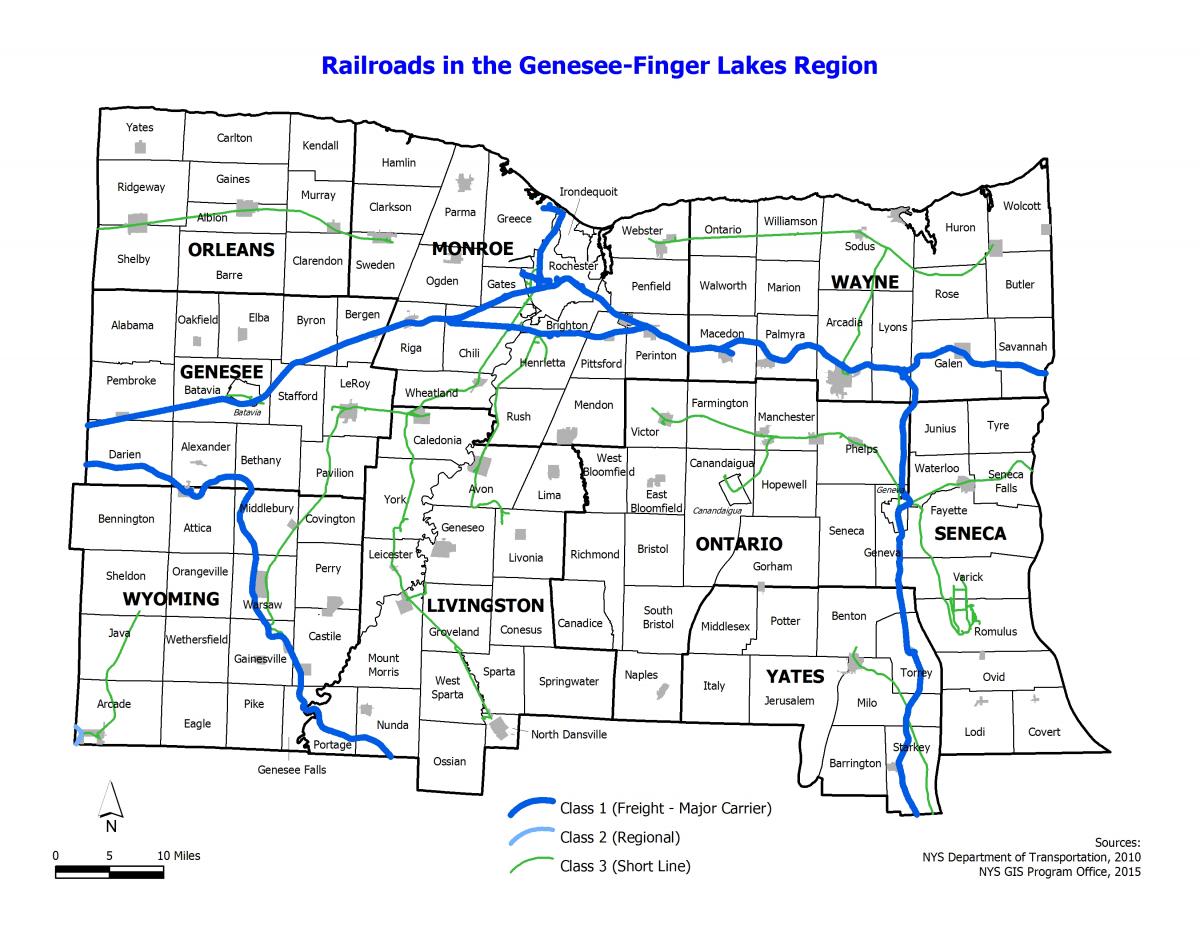
Description: This map depicts the Active Class 1, Class 2 (Regional), and Class 3 (Short Line) Railroads in the Genesee-Finger Lakes Region. Two Class 1 (operating revenues in excess of $378.8 million in 2009) railroads, one Class 2 (revenues less than $378.8 million and greater than $40 million in 2009) railroad, and nearly a dozen Class 3 (revenues less than $40 million in 2009) railroads operate in the region.
Developed For: LRTP 2040
Page Orientation: Landscape
Page Size: 8.5" x 11" (Letter)
Format: JPG [424 KB]
Format: PDF [236 KB]
Interregional Transportation Facilities
![]()
Description: This map depicts the Interregional Transportation Facilities in the Genesee-Finger Lakes Region. Interregional travel facilities provide opportunities for travel into and out of the region.
Developed For: LRTP 2040
Page Orientation: Landscape
Page Size: 8.5" x 11" (Letter)
Format: JPG [339 KB]
Format: PDF [302 KB]
Functional Classification
Description: Functional classification is the process by which roadways are grouped into a hierarchy according to the character of service they provide. Functional Classification helps determine eligibility for federal transportaiton funding.
For more information, and to access the NYSDOT Functional Classification Viewer, please visit the NYSDOT Functional Class Maps page.
Developed By: New York State Department of Transportation
Developed For: FHWA Functional Classification System